Place Hub
St. Augustine Area: Timucua Land, Colony, Fort, Free Black Settlement
Timucua land, colony, fort, free Black settlement
This hub is meant to gather place, records, timelines, prompts, and review lanes in one reading surface so the location becomes more usable than a single isolated claim.
Educational and identity safety note
This project is educational. It does not certify identity, ancestry, tribe, nationality, DNA conclusions, legal status, descent, or membership in any community. Use records, DNA leads, community memory, oral tradition, and spiritual interpretation carefully and label each kind of claim.
This note adds a public boundary to the page: it tells readers that the site is here to improve source use, place reading, and wording discipline, not to replace the harder work of verification.
Place hub decision frame
Best used when
- A reader needs to understand how geography, routes, institutions, public records, and local memory shape a claim before evaluating it.
- The question is too broad for one source and needs a place anchor before moving into Wiki, Field Guides, Source Review, or Fact Check.
- The place itself changes the safest wording: river, road, mound, mission, fort, school, church, cemetery, port, county, or archive context matters.
Reader output
- A narrower question about St. Augustine Area: Timucua Land, Colony, Fort, Free Black Settlement that can be checked against records, maps, source trails, or review workflows.
- A short list of sources to compare next, not a final identity, ancestry, legal-status, or membership conclusion.
- A decision about whether the next page should be a Place Packet, Source Table, Claim Review Card, Community Note, or Fact Check.
Do not use this hub to
- Convert a place name, landscape feature, route, or local story into proof of identity, ancestry, descent, DNA, legal status, tribe, Nation, or membership.
- Treat maps, pins, videos, quizzes, or timelines as stronger than the sources they point toward.
- Publish living-person details, private family material, raw DNA data, or sensitive community information without Safe Sharing review.
Quick facts
These facts are meant to orient the reader quickly to place, period, and institutional context before they move into longer interpretation or stronger claims.
- Modern place
- St. Augustine, Florida
- Waterway
- Matanzas Bay / Atlantic coast
- Region
- Northeast Florida
- 1565 frame
- St. Augustine was established in 1565 on Timucua land
- Castillo
- Ground was broken for Castillo de San Marcos in 1672
- Fort Mose
- Chartered in 1738 as a legally sanctioned free Black settlement
- Fort Matanzas
- Completed in 1742 to guard the southern approach to St. Augustine
Learning path
This list is here to make the current support, uncertainty, sources, or open questions visible at a glance instead of scattering them across the page.
- Begin before 1565 so colonial firsts do not erase existing Indigenous histories.
- Connect Castillo, Fort Mose, Fort Matanzas, Timucua context, missionization, refuge, slavery, and coastal routes as related but distinct paths.
- Teach refuge and slavery together without flattening Spanish, British, and U.S. legal differences.
Research packet
This packet breaks a larger place question into smaller research tasks so readers can move from broad curiosity to documented source work.
Layer Indigenous, Spanish, African, and Atlantic records
St. Augustine is a crossroads; the packet needs multiple archives and clear source origins.
- Separate pre-contact context, Spanish colonial records, Fort Mose context, and later local histories.
- Track language, jurisdiction, and record creator before summarizing a claim.
- Use open questions where the archive is silent or one-sided.
Treat colonial records as partial evidence
Official records can preserve names while also reflecting colonial priorities and power.
- Ask who made the record and why.
- Pair records with archaeology, public history, and later community sources when possible.
- Avoid treating absence from a colonial file as absence from the place.
Build a public-history trail
Visitors need a path from fort interpretation to freedom, labor, mission, and coastal context.
- Link Castillo, Fort Mose, coastal crossroads, and Timucuan context in one source trail.
- Write what each institution can support and what remains open.
- Use Community Notes for corrections to wording or missing context.
Build the freedom, service, and family-source packet
St. Augustine needs a public-history trail that can hold Fort Mose, colonial records, military service, family records, and later memory without flattening them.
- Separate Fort Mose and Spanish colonial context from Civil War, pension, marriage, newspaper, and family-search records.
- Create a source table before turning a refuge, service, or family-search clue into public copy.
- Keep identity, ancestry, DNA, legal-status, descent, tribe, nationality, and membership claims in Source Review.
National Archives - Military Records for GenealogyLibrary of Congress - Chronicling America
Add institution records to the freedom and family-source packet
St. Augustine can hold Fort Mose, colonial context, military service, and later institution records when every source type is labeled.
- Create separate rows for Fort Mose context, church records, cemetery records, schools, Bureau field-office clues, Sanborn sheets, and newspapers.
- Pair service, pension, marriage, church, cemetery, school, and newspaper sources before strengthening a family or community-memory claim.
- Keep identity, ancestry, DNA, legal-status, descent, tribe, nationality, and membership claims in Source Review.
National Archives - The Freedmen's BureauLibrary of Congress - Sanborn Maps
Use field guides for freedom, service, and family claims
St. Augustine attracts strong claims, so the hub needs templates that slow down source work before public wording is strengthened.
- Use the source table template before connecting Fort Mose, colonial context, service, pension, marriage, or family-search clues.
- Use the map and address log for Sanborn sheets, streets, institutions, and later neighborhood context.
- Use the privacy redaction checklist before publishing family, cemetery, school, or living-person details.
FOBA Field GuidesFOBA Source Table TemplateFOBA Source ReviewFOBA Claim Review
Learner prompts
These prompts are meant to turn passive reading into a usable review move: compare, label, question, or route a claim into the right next step.
Before the first
How do you write America begins here without beginning in 1565?
Check: Lead with Indigenous ground before colonial slogans.
Fort Mose lens
What does Fort Mose add to the public story that fort-only narratives miss?
Check: Freedom-seeking history is central, not a footnote.
Regional hub
What is the difference between a regional hub and a first permanent settlement slogan?
Check: A hub can hold competing histories and source limits.
Freedom and family records
Which records can connect Fort Mose, coastal refuge, military service, family search, marriage, and later community memory without making one source do everything?
Check: Freedom, service, refuge, and family claims each need their own source trail.
Institution records after Fort Mose
Which church, cemetery, school, Bureau, Sanborn, and newspaper records help St. Augustine readers connect freedom, refuge, service, and community memory without overclaiming?
Check: Fort Mose, colonial records, military records, and later institutions each need their own source trail.
Template choice
Which template keeps St. Augustine freedom, service, family, and institution claims from becoming one oversized proof claim?
Check: Use source tables and claim review cards before strengthening identity-adjacent language.
Source-review fallback
Which claim would move from method notes into Source Review before public-facing wording changes?
Check: Any translation-name or identity-adjacent claim needs Source Review before stronger language.
Claim review packet path
Where should translators or fact-check gaps be logged when St. Augustine records conflict?
Check: Use claim-review and evidence gates for unresolved identity, translation, or legal-context wording.
What is supported
This list is here to make the current support, uncertainty, sources, or open questions visible at a glance instead of scattering them across the page.
- St. Augustine enduring colonial story begins on Timucua land.
- The region history includes European rivalry, missionization, military construction, and African freedom-seeking.
- Fort Mose and Fort Matanzas belong in the same learning path as Castillo and early Timucua context.
- Castillo de San Marcos interprets a long record of cultural intersections and coastal defense.
- Fort Mose is central to the free Black settlement and refuge story in Spanish Florida.
What is open
This list is here to make the current support, uncertainty, sources, or open questions visible at a glance instead of scattering them across the page.
- How can the site narrate colonial firsts without erasing existing Indigenous histories?
- How should St. Augustine connect to nearby river and coastal routes in the Story Map?
- How can refuge and slavery be taught together without flattening Spanish, British, and U.S. legal differences?
- Which translated records and public-history summaries need fact-check review before quotation?
Major claim labels
This list is here to make the current support, uncertainty, sources, or open questions visible at a glance instead of scattering them across the page.
- Evidence A / Supported: St. Augustine was established in 1565 on Timucua land.
- Evidence A / Supported: Castillo interprets more than 450 years of cultural intersections.
- Evidence B / Strong interpretive caution: A colonial first can erase prior Indigenous histories if written carelessly.
Community and fact-check prompts
These prompts are meant to turn passive reading into a usable review move: compare, label, question, or route a claim into the right next step.
Community Note prompt
Share a source-backed note that helps connect St. Augustine, Fort Mose, Castillo, Fort Matanzas, Timucua context, or coastal routes without exposing living people.
Check: Use an alias if helpful, cite public sources, and do not publish private information about living people.
Fact Check prompt
How can a colonial first be written without erasing prior Indigenous histories?
Check: Split the claim into source-checkable parts before treating it as supported, open, or unsupported.
Claim review frame
This frame adds one disciplined move to public reading: separate the sentence being made, the evidence behind it, the uncertainty around it, and the wording that is actually safe to publish.
What the claim says
Write the claim in one plain sentence before adding interpretation.
What evidence supports
Name the records, maps, archaeology, oral-history notes, or scholarly summaries that can be checked.
What remains debated
Mark interpretation, community memory, spiritual reading, or open questions honestly.
Recommended wording
Use careful wording that does not certify identity, ancestry, tribe, legal status, DNA conclusions, or community membership.
What remains open: A completed frame improves clarity, but it does not settle a claim until the source trail is strong enough and the wording survives review.
Story Map
Use the map to compare place hubs, rivers, routes, and research questions. A text list is included for readers who prefer not to use the map.
This map adds spatial orientation and comparison. It helps readers see where questions cluster, but the pins should still be read beside records, timelines, and source trails rather than as proof by themselves.
Map evidence boundary
- Pins orient a reader to a place, route, or cluster; they do not prove identity, descent, jurisdiction, migration, or community membership.
- A mapped pattern should become a better research question before it becomes a stronger claim.
- Use the relevant place hub, source trail, and claim-review workflow before reusing a map observation elsewhere.
Map Places
- Montezuma, Georgia: River Crossing, Railroad Town, Flood Memory River crossing, railroad town, flood memory
- Macon-Ocmulgee: Mounds, River, Homeland Mounds, river, homeland
- Cartersville-Etowah: Mounds, Plaza, River Fish Trap Mounds, plaza, river fish trap
- Blakely-Kolomoki: Woodland Red Earth Woodland red earth
- Tallahassee-Lake Jackson: Fort Walton Crossroads Fort Walton crossroads
- Jacksonville-Timucuan: River, Marsh, Contact, Plantation River, marsh, contact, plantation
- St. Augustine Area: Timucua Land, Colony, Fort, Free Black Settlement Timucua land, colony, fort, free Black settlement
This timeline adds order and sequence so readers can compare events, period labels, and caution notes before turning chronology into a stronger claim.
Timeline evidence boundary
- Sequence is context, not proof. A date appearing before or after another date does not by itself establish cause, identity, continuity, or authority.
- Period labels are reading aids. Treat them as prompts to compare records, wording, and local conditions, not as final categories.
- When a timeline changes how a claim sounds, route the claim through Source Review or Claim Review before publishing it as settled.
- Generic identity, ancestry, descent, legal-status, DNA, and membership cautions apply to every row, so repeated row-level versions are suppressed unless a row has a more specific care note.
Use this timeline to compare sequence, period labels, and caution notes. It helps order the evidence, but chronology alone does not settle a claim.
Industrial
- 1871–1880 Southern Claims Commission generates witness-rich case files
Connects rail, Reconstruction, public history, preservation, and archival records to research practice.
- 1865–1874 Freedman’s Bank creates unusually rich African American family records
Connects rail, Reconstruction, public history, preservation, and archival records to research practice.
- 1865 Freedmen’s Bureau begins creating crucial postwar records
Connects rail, Reconstruction, public history, preservation, and archival records to research practice.
Treaty-Land Reorganization
- 1830s Seminole refuge and conflict histories reshape Florida and Georgia reading paths
Marks land policy, roads, treaty pressure, and forced removal as disruptive and record-producing contexts.
Contact-Colonial
- 1742 Fort Matanzas completed
Places colonial records, conflict, missionization, refuge, and contact-era disruption in a source-labeled frame.
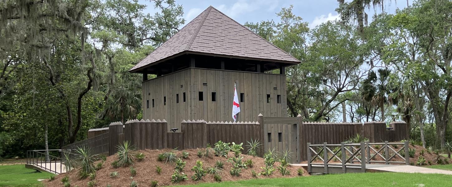
- 1738 Fort Mose chartered as free Black settlement
Places colonial records, conflict, missionization, refuge, and contact-era disruption in a source-labeled frame.
- 1738 Fort Mose anchors a freedom-seeking Black history path
Fort Mose requires the hub to connect Spanish Florida, refuge from enslavement, free Black community, militia service, and public memory with careful source labels.
- 1672 Ground broken for Castillo de San Marcos
Places colonial records, conflict, missionization, refuge, and contact-era disruption in a source-labeled frame.
- 1672 onward Castillo de San Marcos becomes a major colonial record anchor
The fort is a source path into military, labor, trade, coastal defense, and cultural-intersection histories, but it should not be the only lens on the area.
- 1565 Matanzas massacre secures Spanish control and leaves a place-name legacy
Places colonial records, conflict, missionization, refuge, and contact-era disruption in a source-labeled frame.
- 1565 Menéndez establishes St. Augustine on Timucua land
Places colonial records, conflict, missionization, refuge, and contact-era disruption in a source-labeled frame.
- 1565 onward St. Augustine becomes a colonial crossroads
The hub uses the area to teach how colonial records, missions, and coastal life intersect.
- 1513 Ponce de León claims Florida for Spain
Places colonial records, conflict, missionization, refuge, and contact-era disruption in a source-labeled frame.
Mound Cities
- mound era Comparing Ocmulgee, Etowah, Kolomoki, and Lake Jackson requires period labels up front
Supports careful comparison of civic landscapes while keeping local periods distinct.
- mound era Platform mounds, plazas, and surrounding residences form recurring civic landscapes
Supports careful comparison of civic landscapes while keeping local periods distinct.
Woodland
- Woodland era “Big mound” does not equal one culture or one era
Keeps Woodland chronology visible before later mound-center comparisons.
- Woodland era Woodland chronology remains crucial for north Florida and southwest Georgia comparison
Keeps Woodland chronology visible before later mound-center comparisons.
- Woodland era Earthen mounds emerge as long-duration social and ceremonial architecture
Keeps Woodland chronology visible before later mound-center comparisons.
- Woodland era Regional communities across Florida and Georgia develop distinct pottery styles
Keeps Woodland chronology visible before later mound-center comparisons.
- Woodland era Public interpretation must avoid reclassifying Kolomoki as generic Mississippian
Keeps Woodland chronology visible before later mound-center comparisons.
Paleoindian-Early Peoples
- c. 1000 BCE onward Regional cultural variation deepens across the Southeast
Frames long human presence and environmental change without treating early periods as empty land.
- c. 4000 BCE onward Florida communities intensify aquatic food use and pottery traditions
Frames long human presence and environmental change without treating early periods as empty land.
- early period Later place hubs should treat deep time as human history, not prehistory-as-empty-land
Frames long human presence and environmental change without treating early periods as empty land.
- early period Early Florida landscapes include now-submerged or transformed coastal zones
Frames long human presence and environmental change without treating early periods as empty land.
- early period Early peoples in Florida use river and coastal resources heavily
Frames long human presence and environmental change without treating early periods as empty land.
- early period Hunting and gathering dominate before later agricultural intensification
Frames long human presence and environmental change without treating early periods as empty land.
- early millennia Rivers become enduring travel and settlement corridors
Frames long human presence and environmental change without treating early periods as empty land.
- c. 12,000 years ago People occupy a larger, drier Florida peninsula
Frames long human presence and environmental change without treating early periods as empty land.

Related Wiki
These related entries extend the same place question through nearby source lanes so the reader can compare context instead of relying on one page alone.
These recent entries show where source trails, place anchors, or claim labels have changed most recently.
Use this strip to find the pages where the site is adding new synthesis or narrowing risky wording right now, not just the pages with the newest timestamps.
Related Tales
These related entries extend the same place question through nearby source lanes so the reader can compare context instead of relying on one page alone.
These recent tales show where the project is using labeled narrative and memory work to support learning without treating story as proof.
Use this strip when you need reflection, teaching, or memory context that stays clearly separated from source certification.
Micro Quiz
Selections are saved only in this browser. No answers are sent to the site.
This quiz adds a quick comprehension check so readers can test whether they are noticing labels, sources, and review boundaries instead of only skimming the page.
Quiz use boundary
- The quiz is not a certification, scorecard, identity test, or proof that a reader understands the whole topic.
- Selections stay in the browser. Missed answers should send the reader back to labels, sources, and review limits, not toward shame or certainty theater.
- Use the result to choose a next review step: reread the place hub, build a source table, prepare a claim review card, or ask a fact-check question.
Media candidates to verify
This list is here to make the current support, uncertainty, sources, or open questions visible at a glance instead of scattering them across the page.
- Castillo exterior image from NPS - caption fort and labor context carefully
- Who Built the Castillo illustration or page asset - verify rights and use for labor/engineering context
- Fort Mose image or timeline from Florida State Parks - verify rights and center freedom-seeking context
Sources to seek
This list is here to make the current support, uncertainty, sources, or open questions visible at a glance instead of scattering them across the page.
- NPS Castillo, Fort Matanzas, St. Augustine Town Plan, and early peoples pages
- Florida State Parks Fort Mose history and public-history resources
- Mission-era, Spanish colonial, translation, coastal archaeology, and Timucua context sources
- St. Augustine church, cemetery, school, Bureau, Sanborn, military, pension, marriage, and newspaper sources that can support Fort Mose and later community-history packets without certification language
Source trail
This list is here to make the current support, uncertainty, sources, or open questions visible at a glance instead of scattering them across the page.
- National Park Service - Castillo de San Marcos National Monument Use for fort, Atlantic trade route, and cultural-intersection context.
- Florida State Parks - Fort Mose Historic State Park Use for free Black settlement, refuge, and visitor interpretation context.
- NPS St. Augustine Town Plan page Source-trail item from the research package; verify exact citation before expanding public claims.
- Castillo homepage and Who Built the Castillo page Source-trail item from the research package; verify exact citation before expanding public claims.
- Fort Mose history page Source-trail item from the research package; verify exact citation before expanding public claims.
- Fort Matanzas overview and massacre page Source-trail item from the research package; verify exact citation before expanding public claims.
- Fort Matanzas Early Peoples page Source-trail item from the research package; verify exact citation before expanding public claims.
Partner learning path
Use both sites without collapsing their meanings
TheFoundationsOf.us focuses on foundations, Muur history, ancestral memory, place-based research, and community learning. MoorofUs.org provides evidence-first Moor history, people, places, timelines, claims, and sources. CultureUP.us carries broader culture and media coverage with visible source context.
What this partner path adds
- It helps readers move between related projects without assuming they make the same kind of claim.
- It reduces confusion by clarifying which site is best for foundations, which is best for wider Moor history, and which is best for broader cultural coverage.
- It keeps the network useful by turning cross-site travel into a source-aware decision instead of a branding shortcut.
Cross-site evidence boundary
- A link to a partner site is a reading route, not an endorsement that every claim on both pages has the same evidence level.
- Do not move language from one site into another without preserving the source label, claim status, privacy limits, and date of the page being cited.
- If a partner page changes the strength of a claim, treat the next step as source review or fact check rather than automatic republication.
Reader handoff output
You should leave knowing which site fits the question you actually have, what evidence boundary traveled with you, and what review lane is needed before cross-site language becomes public wording.