Place Hub
Jacksonville-Timucuan: River, Marsh, Contact, Plantation
River, marsh, contact, plantation
This hub is meant to gather place, records, timelines, prompts, and review lanes in one reading surface so the location becomes more usable than a single isolated claim.
Educational and identity safety note
This project is educational. It does not certify identity, ancestry, tribe, nationality, DNA conclusions, legal status, descent, or membership in any community. Use records, DNA leads, community memory, oral tradition, and spiritual interpretation carefully and label each kind of claim.
This note adds a public boundary to the page: it tells readers that the site is here to improve source use, place reading, and wording discipline, not to replace the harder work of verification.
Place hub decision frame
Best used when
- A reader needs to understand how geography, routes, institutions, public records, and local memory shape a claim before evaluating it.
- The question is too broad for one source and needs a place anchor before moving into Wiki, Field Guides, Source Review, or Fact Check.
- The place itself changes the safest wording: river, road, mound, mission, fort, school, church, cemetery, port, county, or archive context matters.
Reader output
- A narrower question about Jacksonville-Timucuan: River, Marsh, Contact, Plantation that can be checked against records, maps, source trails, or review workflows.
- A short list of sources to compare next, not a final identity, ancestry, legal-status, or membership conclusion.
- A decision about whether the next page should be a Place Packet, Source Table, Claim Review Card, Community Note, or Fact Check.
Do not use this hub to
- Convert a place name, landscape feature, route, or local story into proof of identity, ancestry, descent, DNA, legal status, tribe, Nation, or membership.
- Treat maps, pins, videos, quizzes, or timelines as stronger than the sources they point toward.
- Publish living-person details, private family material, raw DNA data, or sensitive community information without Safe Sharing review.
Quick facts
These facts are meant to orient the reader quickly to place, period, and institutional context before they move into longer interpretation or stronger claims.
- Modern place
- Jacksonville, Florida
- Waterway
- Lower St. Johns / coastal marsh / Fort George area
- Region
- Northeast Florida
- Time depth
- Roughly 6,000 years of human history in preserve interpretation
- Signature sites
- Fort Caroline and Kingsley Plantation
- Terminology care
- Timucua refers to related language communities, not one single centralized polity
- Black history frame
- Kingsley Plantation preserves major material evidence of slavery, free Black life, and shifting Spanish/U.S. regimes
Learning path
This list is here to make the current support, uncertainty, sources, or open questions visible at a glance instead of scattering them across the page.
- Start with water: St. Johns River, marsh, islands, coast, and travel before naming forts or plantations.
- Teach Timucua-speaking communities with language-community caution instead of a single-polity shortcut.
- Connect Indigenous, French, Spanish, plantation, slavery, free Black, ecology, and preservation layers without collapsing them.
Research packet
This packet breaks a larger place question into smaller research tasks so readers can move from broad curiosity to documented source work.
Start with coast, river, and marsh
The Timucuan Preserve hub depends on environmental context as much as named sites.
- Create a landscape note for river, coast, marsh, island, shell, and movement.
- Separate ecological evidence from contact-era records and modern interpretation.
- Use the Story Map to connect Jacksonville, Timucuan, St. Johns, and St. Augustine.
Read contact-era terms cautiously
Names in colonial records can reveal and distort at the same time.
- Record who created a term, when, and for what purpose.
- Avoid applying one contact-era label backward across every period.
- Send translation or identity questions to Fact Check.
Protect community and descendant context
Coastal histories can touch living communities and sensitive family research.
- Share public citations rather than private family material.
- Use pseudonyms where public attribution is not needed.
- Keep Tales labeled so story never replaces evidence.
Build the coastal movement and labor packet
Jacksonville-Timucuan history touches Indigenous, plantation, labor, migration, and family-search layers that need careful separation.
- Separate environmental context, contact-era records, plantation records, labor records, family-search notices, and later civic records.
- Pair migration letters, missing-family ads, pension files, court records, and newspapers with place and privacy review.
- Use open wording until a person, date, place, and movement are supported by records.
Library of Congress - Chronicling AmericaNational Archives - African American History Resources
Add urban Black institution and map layers
Jacksonville-Timucuan can teach coastal landscape history and urban institution research when the layers remain clearly separated.
- Create separate rows for Timucuan/coastal context, plantation context, Sanborn maps, directories, businesses, mutual aid, cemeteries, and Bureau records.
- Pair directories and Sanborn sheets with deeds, tax records, newspapers, church records, cemetery files, and safe oral history.
- Keep movement, status, ownership, identity, and descent claims in Source Review until supported by multiple record types.
Library of Congress - Sanborn MapsLibrary of Congress - African Americans in Business and Entrepreneurship
Prepare a coastal and urban field-guide packet
The hub can hold Timucuan, plantation, urban institution, and Black records context when templates keep source types separate.
- Use the place packet template for coastal landscape and route context.
- Use the institution packet template for churches, cemeteries, businesses, mutual aid, and Bureau clues.
- Use the privacy redaction checklist before publishing living-family, cemetery, or neighborhood details.
FOBA Field GuidesFOBA Privacy Redaction ChecklistFOBA Source ReviewFOBA Claim Review
Learner prompts
These prompts are meant to turn passive reading into a usable review move: compare, label, question, or route a claim into the right next step.
Timucua wording
Why is it misleading to write the Timucua as if they were one single polity?
Check: Use language-community and source-context labels.
Layered landscape
What happens when a place hub links Indigenous history and plantation history in one landscape?
Check: Connection is not collapse.
Water matters
How should river and marsh ecology change the way a reader imagines settlement?
Check: Environment shapes evidence and movement.
Movement with care
Which records could connect river, coast, plantation, labor, family search, and movement without collapsing the layers?
Check: A route explains possibility; people-centered records must carry migration claims.
Urban and coastal institutions
How can Jacksonville records connect river, coast, plantation, city directories, Sanborn maps, Black business, cemeteries, and mutual aid without letting one layer replace another?
Check: A city map or directory gives context; people-centered and institution-centered records must carry specific claims.
Template choice
When should a Jacksonville-Timucuan note use a place packet, institution packet, map log, or privacy checklist?
Check: Coastal, urban, plantation, and family records need different template lanes.
Source review route
Before strengthening a Jacksonville claim, which page should be checked first: source-review, claim-review, or field guides?
Check: Route high-risk claims through source-review and claim-review before updating broad landing copy.
Evidence gate for wharf permits
Does the wharf permit packet page include enough corroboration and date context to support a place claim?
Check: Keep permit and labor evidence in context lanes before any continuity wording.
What is supported
This list is here to make the current support, uncertainty, sources, or open questions visible at a glance instead of scattering them across the page.
- Timucuan history in this region long predates European colonization.
- Sixteenth-century first-contact history is central here.
- Kingsley Plantation is essential for bringing Black history into the same regional packet.
- The preserve is a water-and-marsh landscape as much as a set of historic sites.
- The preserve links ecology, archaeology, public history, and visitor interpretation.
What is open
This list is here to make the current support, uncertainty, sources, or open questions visible at a glance instead of scattering them across the page.
- How much should the Jacksonville hub foreground ecology versus fort and plantation history?
- Does Timucua need a recurring glossary label on all related pages?
- How should Indigenous history be sequenced before colonial history so the latter does not swallow the former?
- Which Black Atlantic and local records can deepen the Kingsley packet without exposing living-person information?
Major claim labels
This list is here to make the current support, uncertainty, sources, or open questions visible at a glance instead of scattering them across the page.
- Evidence A / Supported: Timucuan Preserve holds roughly 6,000 years of human history.
- Evidence B / Incorrect as phrased: Timucua were one politically unified nation.
- Evidence B / Strong interpretive recommendation: Kingsley Plantation belongs in the same educational packet as early Indigenous history.
Community and fact-check prompts
These prompts are meant to turn passive reading into a usable review move: compare, label, question, or route a claim into the right next step.
Community Note prompt
Using an alias, share a source lead that helps connect St. Johns River, marsh, Fort Caroline, Kingsley, or local community memory without exposing living people.
Check: Use an alias if helpful, cite public sources, and do not publish private information about living people.
Fact Check prompt
Were Timucua-speaking communities one unified centralized political nation?
Check: Split the claim into source-checkable parts before treating it as supported, open, or unsupported.
Claim review frame
This frame adds one disciplined move to public reading: separate the sentence being made, the evidence behind it, the uncertainty around it, and the wording that is actually safe to publish.
What the claim says
Write the claim in one plain sentence before adding interpretation.
What evidence supports
Name the records, maps, archaeology, oral-history notes, or scholarly summaries that can be checked.
What remains debated
Mark interpretation, community memory, spiritual reading, or open questions honestly.
Recommended wording
Use careful wording that does not certify identity, ancestry, tribe, legal status, DNA conclusions, or community membership.
What remains open: A completed frame improves clarity, but it does not settle a claim until the source trail is strong enough and the wording survives review.
Story Map
Use the map to compare place hubs, rivers, routes, and research questions. A text list is included for readers who prefer not to use the map.
This map adds spatial orientation and comparison. It helps readers see where questions cluster, but the pins should still be read beside records, timelines, and source trails rather than as proof by themselves.
Map evidence boundary
- Pins orient a reader to a place, route, or cluster; they do not prove identity, descent, jurisdiction, migration, or community membership.
- A mapped pattern should become a better research question before it becomes a stronger claim.
- Use the relevant place hub, source trail, and claim-review workflow before reusing a map observation elsewhere.
Map Places
- Montezuma, Georgia: River Crossing, Railroad Town, Flood Memory River crossing, railroad town, flood memory
- Macon-Ocmulgee: Mounds, River, Homeland Mounds, river, homeland
- Cartersville-Etowah: Mounds, Plaza, River Fish Trap Mounds, plaza, river fish trap
- Blakely-Kolomoki: Woodland Red Earth Woodland red earth
- Tallahassee-Lake Jackson: Fort Walton Crossroads Fort Walton crossroads
- Jacksonville-Timucuan: River, Marsh, Contact, Plantation River, marsh, contact, plantation
- St. Augustine Area: Timucua Land, Colony, Fort, Free Black Settlement Timucua land, colony, fort, free Black settlement
This timeline adds order and sequence so readers can compare events, period labels, and caution notes before turning chronology into a stronger claim.
Timeline evidence boundary
- Sequence is context, not proof. A date appearing before or after another date does not by itself establish cause, identity, continuity, or authority.
- Period labels are reading aids. Treat them as prompts to compare records, wording, and local conditions, not as final categories.
- When a timeline changes how a claim sounds, route the claim through Source Review or Claim Review before publishing it as settled.
- Generic identity, ancestry, descent, legal-status, DNA, and membership cautions apply to every row, so repeated row-level versions are suppressed unless a row has a more specific care note.
Use this timeline to compare sequence, period labels, and caution notes. It helps order the evidence, but chronology alone does not settle a claim.
Industrial
- 1990 National Park Service preserve context expands public interpretation
Modern preservation brings ecology, archaeology, public history, and visitor interpretation into the same learning frame.
- 1988 Timucuan Preserve established
Connects rail, Reconstruction, public history, preservation, and archival records to research practice.
- 1871–1880 Southern Claims Commission generates witness-rich case files
Connects rail, Reconstruction, public history, preservation, and archival records to research practice.
- 1865–1874 Freedman’s Bank creates unusually rich African American family records
Connects rail, Reconstruction, public history, preservation, and archival records to research practice.
- 1865 Freedmen’s Bureau begins creating crucial postwar records
Connects rail, Reconstruction, public history, preservation, and archival records to research practice.
- nineteenth century Kingsley stories of slavery and free Black landholding become central to lower St. Johns interpretation
Connects rail, Reconstruction, public history, preservation, and archival records to research practice.
Treaty-Land Reorganization
- 1830s Seminole refuge and conflict histories reshape Florida and Georgia reading paths
Marks land policy, roads, treaty pressure, and forced removal as disruptive and record-producing contexts.
Contact-Colonial
- eighteenth century Kingsley/plantation-era precedents grow from wider Spanish Florida labor systems
Places colonial records, conflict, missionization, refuge, and contact-era disruption in a source-labeled frame.
- 1500s-1600s Contact-era changes affect coastal communities
The hub should label disruption, mission systems, alliances, and disease impacts carefully.
- sixteenth century Fort Caroline marks a short-lived French presence and first-contact zone
Places colonial records, conflict, missionization, refuge, and contact-era disruption in a source-labeled frame.
Mound Cities
- mound era Comparing Ocmulgee, Etowah, Kolomoki, and Lake Jackson requires period labels up front
Supports careful comparison of civic landscapes while keeping local periods distinct.
- mound era Platform mounds, plazas, and surrounding residences form recurring civic landscapes
Supports careful comparison of civic landscapes while keeping local periods distinct.
Woodland
- Woodland era “Big mound” does not equal one culture or one era
Keeps Woodland chronology visible before later mound-center comparisons.
- Woodland era Woodland chronology remains crucial for north Florida and southwest Georgia comparison
Keeps Woodland chronology visible before later mound-center comparisons.
- Woodland era Earthen mounds emerge as long-duration social and ceremonial architecture
Keeps Woodland chronology visible before later mound-center comparisons.
- Woodland era Regional communities across Florida and Georgia develop distinct pottery styles
Keeps Woodland chronology visible before later mound-center comparisons.
- Woodland era Public interpretation must avoid reclassifying Kolomoki as generic Mississippian
Keeps Woodland chronology visible before later mound-center comparisons.
Paleoindian-Early Peoples
- c. 1000 BCE onward Regional cultural variation deepens across the Southeast
Frames long human presence and environmental change without treating early periods as empty land.
- c. 4000 BCE onward Florida communities intensify aquatic food use and pottery traditions
Frames long human presence and environmental change without treating early periods as empty land.
- early period Later place hubs should treat deep time as human history, not prehistory-as-empty-land
Frames long human presence and environmental change without treating early periods as empty land.
- early period Early peoples in Florida use river and coastal resources heavily
Frames long human presence and environmental change without treating early periods as empty land.
- early period Hunting and gathering dominate before later agricultural intensification
Frames long human presence and environmental change without treating early periods as empty land.
- early millennia Rivers become enduring travel and settlement corridors
Frames long human presence and environmental change without treating early periods as empty land.
- c. 12,000 years ago People occupy a larger, drier Florida peninsula
Frames long human presence and environmental change without treating early periods as empty land.

Related Wiki
These related entries extend the same place question through nearby source lanes so the reader can compare context instead of relying on one page alone.
These recent entries show where source trails, place anchors, or claim labels have changed most recently.
Use this strip to find the pages where the site is adding new synthesis or narrowing risky wording right now, not just the pages with the newest timestamps.
Related Tales
These related entries extend the same place question through nearby source lanes so the reader can compare context instead of relying on one page alone.
These recent tales show where the project is using labeled narrative and memory work to support learning without treating story as proof.
Use this strip when you need reflection, teaching, or memory context that stays clearly separated from source certification.
Micro Quiz
Selections are saved only in this browser. No answers are sent to the site.
This quiz adds a quick comprehension check so readers can test whether they are noticing labels, sources, and review boundaries instead of only skimming the page.
Quiz use boundary
- The quiz is not a certification, scorecard, identity test, or proof that a reader understands the whole topic.
- Selections stay in the browser. Missed answers should send the reader back to labels, sources, and review limits, not toward shame or certainty theater.
- Use the result to choose a next review step: reread the place hub, build a source table, prepare a claim review card, or ask a fact-check question.
Media candidates to verify
This list is here to make the current support, uncertainty, sources, or open questions visible at a glance instead of scattering them across the page.
- Timucuan marsh panorama from NPS - likely government-managed but verify and add place label
- Fort Caroline memorial image from NPS - use as contact-era public-history context, not reconstruction proof
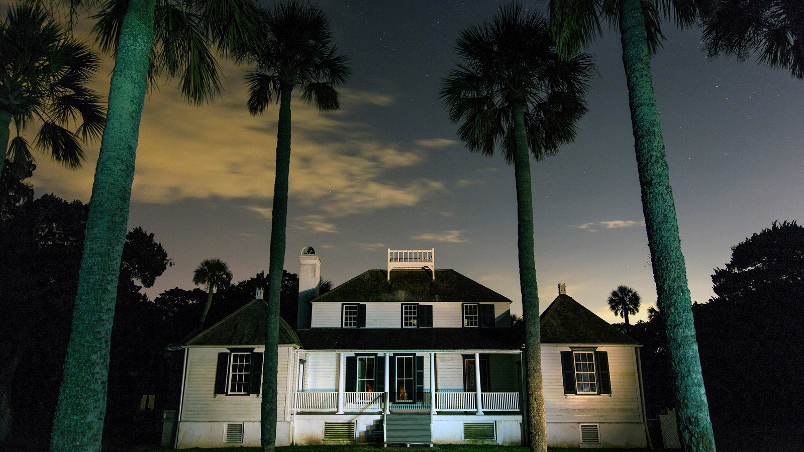
- Kingsley Plantation house or tabby cabin image from NPS - caption labor, slavery, and material culture carefully
Sources to seek
This list is here to make the current support, uncertainty, sources, or open questions visible at a glance instead of scattering them across the page.
- NPS Timucuan Preserve history, Timucua, Fort Caroline, Kingsley, collection, map, and brochure pages
- Coastal archaeology summaries about shell, marsh, islands, and riverine settlement
- Contact-era and plantation-era sources with clear source labels and privacy review
- Jacksonville Sanborn sheets, city directories, Black business notices, mutual-aid notices, cemetery records, Bureau references, church histories, and coastal place records with privacy review
Source trail
This list is here to make the current support, uncertainty, sources, or open questions visible at a glance instead of scattering them across the page.
- National Park Service - Timucuan brochure and map text Use for preserve-wide ecology and public-history framing.
- National Park Service - Timucuan Preserve collections Use for collection and archive prompts.
- Timucuan Preserve history and culture pages Source-trail item from the research package; verify exact citation before expanding public claims.
- NPS Timucua people page Source-trail item from the research package; verify exact citation before expanding public claims.
- Fort Caroline page Source-trail item from the research package; verify exact citation before expanding public claims.
- Timucuan Preserve homepage Source-trail item from the research package; verify exact citation before expanding public claims.
- Kingsley Plantation pages Source-trail item from the research package; verify exact citation before expanding public claims.
Partner learning path
Use both sites without collapsing their meanings
TheFoundationsOf.us focuses on foundations, Muur history, ancestral memory, place-based research, and community learning. MoorofUs.org provides evidence-first Moor history, people, places, timelines, claims, and sources. CultureUP.us carries broader culture and media coverage with visible source context.
What this partner path adds
- It helps readers move between related projects without assuming they make the same kind of claim.
- It reduces confusion by clarifying which site is best for foundations, which is best for wider Moor history, and which is best for broader cultural coverage.
- It keeps the network useful by turning cross-site travel into a source-aware decision instead of a branding shortcut.
Cross-site evidence boundary
- A link to a partner site is a reading route, not an endorsement that every claim on both pages has the same evidence level.
- Do not move language from one site into another without preserving the source label, claim status, privacy limits, and date of the page being cited.
- If a partner page changes the strength of a claim, treat the next step as source review or fact check rather than automatic republication.
Reader handoff output
You should leave knowing which site fits the question you actually have, what evidence boundary traveled with you, and what review lane is needed before cross-site language becomes public wording.